Sueno’s Stone, at Forres, Morayshire

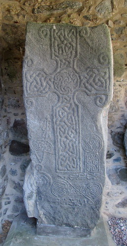
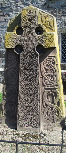
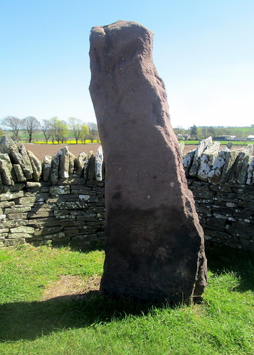
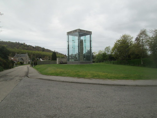
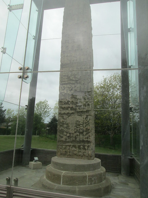
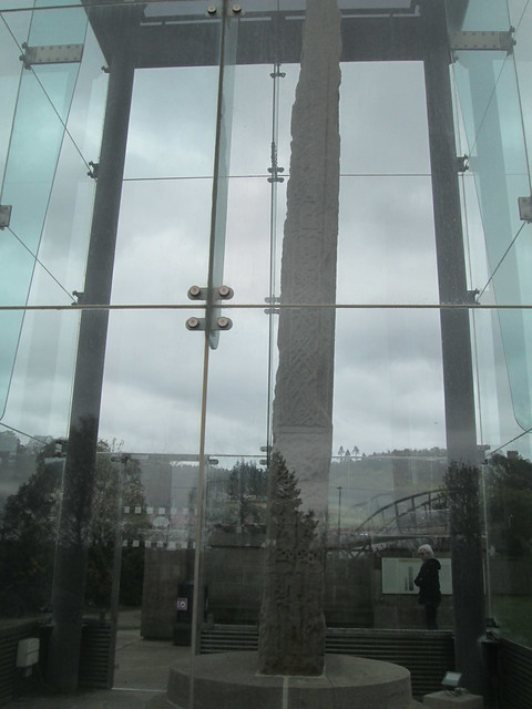
When we visited Elgin back in May one of the places on our list of places/things to visit was Sueno’s Stone on the outskirts of Forres. It’s enormous, 21 feet of ninth century stone, intricately carved with Pictish designs and possibly depicting a battle. The monolith has had a glass enclosure erected around it in recent years to protect it from the elements, as you can imagine the weather can be severe up there in winter.

Sueno's Stone, Forres

The designs are very detailed and are on all of the stone’s surfaces, so we were there quite a while taking photos and examining the designs.

Sueno's Stone Closer view

Apparently there’s a tale locally that the stone is where Macbeth met the three witches and that their souls are trapped inside the stone. It’s believed that the stone is in its original position, some Pictish stones have been relocated over the years apparently.

Sueno's Stone, Side View

While we were there a man arrived and quickly walked around the stone using his phone to video it, at no point did he actually look at the stone, apart from through his phone, and within 90 seconds he was off, no doubt to the next thing of interest and probably uploading it to Facebook as he went! That’s modern life for some I suppose!

Vindolanda – a Roman Fort, Northumberland, England

Fort from Gate, Vindolanda

It was way back in April that we visited the Roman camp at Vindolanda, as you can see from the photo above it’s still a very rural and scenic part of the country.

There are still excavations ongoing here but the photo below is of a replica gateway, to give an idea of what it would have looked like when the Romans were here.

Replica Tower, Vindolanda

Below is a model of the whole camp which is in the on site museum.

Model of Roman Fort at Vindolanda

Some of the remains that have been dug out look quite well preserved as you can see below.

Remains of Fort, Vindolanda

Below you can see the remains of a hypocaust, their heating system. They had all ‘mod cons’ those Romans in Britain, they needed it as it’s a really cold area of England, in the autumn and winter.
A Hypocaust at Vindolanda

Fort Ruins, Vindolanda

They’ve built a replica temple which is well situated by the wee river, a good place to rest and have a coffee.
Replica Temple, Vindolanda

You can read about Vindolanda here and here. The Romans were in this area of North East England (Northumberland) from around 85 AD to 370 AD.

Dyce Symbol Stones, Saint Fergus’s Church, Aberdeenshire, Scotland

We visited several standing stones and symbol stones while we were in Aberdeenshire recently, including the stones at the ruin of Saint Fergus’s Church in Dyce.

Dyce Symbol Stones  info board, Aberdeenshire

As you can see from the photo below it was a sunny day, the stones are just behind the front wall which you can see below.

Dyce Symbol Stones St Fergus's Church

They’ve built a wee canopy to keep the worst of the weather off them. The church itself dates from the 13th century, but the Pictish symbol stones date from the 800s and they’re in remarkably good condition.
Dyce Symbol Stones , St Fergus' Church, Aberdeenshire

Dyce Symbol Stones , Aberdeenshire, Pictish

Dyce Symbol Stones, Pictish, Aberdeenshire
Dyce Symbol Stones, Aberdeenshire, Scotland

Before the 13th century church there was probably a wooden church on the site which would have had these stones as decoration, there’s also part of a broken font. We weren’t the only people looking at the stones, there was a lovely man who was a retired stonemason and he had worked on the church years before, so he pointed out things of interest to us, incuding the ‘green mannie’ on the corner of the building which you can just see in the photo below, he had actually discovered it when he was repointing the church, you might have to click to enlarge it. I always think of the green man as being a Celtic symbol, but he was also popular in England I believe, supposed to be a good luck symbol.

Dyce Symbol Stones Green Man

They certainly chose a beautiful location for the church as just across the road from it is the River Don in the photo below, there are just a few houses in this area, what a great view they wake up to in the morning!

Dyce River Don, Aberdeenshire

Dyce River Don, Aberdeenshire

Dyce River Don, Aberdeenshire

Tomnaverie Stone Circle, Aberdeenshire, Scotland

When we were in Aberdeenshire last weekend we visited quite a few ancient stones such as standing stones and Pictish symbol stones. They’re all in rural locations and there were probably far more of them than you can see today, each community would have had their own, they’re probably a place of worship. Tomnaverie Stone Circle is the largest site that we visited.

Tomnaverie Stone Circle, Aberdeenshire, Scotland

Tomnaverie Stone Circle , standing stones, Aberdeenshire, Scotland

I think I’ve only been to one other which has a large recumbent stone, you can’t help thinking that it looks exactly like an altar, I did have a fleeting thought that it might be a good idea to lie down on it – just to see what it felt like – but I decided against it, just in case it was bad luck!

Tomnaverie Stone Circle, Lochnagar

Lochnagar, which confusingly is actually a mountain can be seen in the distance and it’s thought that whoever built the standing stones may have aligned the altar stone with the mountain. This type of monument is only found in north-east Aberdeenshire.

Tomnaverie Stone Circle, Aberdeenshire, Scotland

This area is very rural, it’s in the middle of nowhere, but you have to hike past the nuclear bunker in the photo below to get to the standing stones!! I wonder who was supposed to use it.

Tomnaverie Stone Circle Nuclear Bunker 2

Cuween Chambered Cairn, Orkney, Scotland

Cuween Cairn, Orkney, Neolithic Chamber, burial

The Cuween Burial Chambered Cairn is accessed by the original doorway, which means that you have to crawl in. I was wary of getting my knees muddy though so I did a sort of elongated crawl, with my legs and arms stretched out.

Cuween Chambered Cairn, Orkney, Scotland, Neolithic

Cuween Chambered Cairn Board

Inside it’s quite roomy compared with some others.

Cuween, Inside cairn, Neolithic, Orkney

There’s plenty of space to stand up in once you get through the tunnel entrance.

Cuween, Inside cairn, Neolithic, Orkney

Cuween, Inside cairn , Neolithic, Orkney

The side chambers are much bigger, I suppose that’s where the people were placed, with animals. I crawled halfway into the one below to get a pohoto of inside it, the dark shadow is my phone! The roof in the side chamber was low, well the dead don’t need to stand up I suppose! I would not have liked to go any further, it felt very claustraphobic – and a wee bit spooky.

Cuween, Inside cairn 3 side chamber

Cuween Chambered Cairn is around 5,000 years old, but wasn’t excavated until 1901. It contained human and animal bones.

Inside cairn, Cuween, Neolithic, Orkney

I don’t think I would have gone into any of these burial cairns on my own, as you can see I had Jack with me. It was definitely worth visiting this one though and it was a plus to have it all to ourselves so we could take our time having a good look at it.

Cuween, Inside cairn, Orkney, Neolithic,

Skara Brae, Skaill Bay, Orkney, Scotland

One place that I suspect everyone visiting Orkney makes for first is Skara Brae, a 5,000 year old neolithic settlement which was uncovered after a huge storm in 1850 displaced the sand that had been hiding it for thousands of years. It does look very like The Flintstones with the furniture being made of stone. I rather like the ‘sideboard’ which is situated opposite the front door, pride of place.

Skara Brae, Orkney, neolithic dwelling, Scotland

There are the remains of several different buildings, one of which seems to have been a workshop.

Skara Brae, neolithic dwelling, Scotland

There is a reconstruction of a house on the site too, but it’s dark and was full of people (quiet scary nowadays) so it wasn’t possible to take photos. But you can see some photos here.

Skara Brae, neolithic dwelling, Orkney, Scotland

Skara Brae, Orkney, neolithic dwelling, Scotland

Skara Brae, neolithis settlement, Orkney, Scotland

Skara Brae Map, Orkney, Scotland, plan

As the site is right on the edge of the sea it’s only a matter of time before it’s lost completely as the rough weather will eventually overcome the area and wash it all away, I wonder how much has already been lost.

Bay of Skaill, Orkney, Scotland

Brough of Birsay, Orkney, Scotland

Mainland Orkney from Birsay

While we were on Orkney on holiday recently we decided to revisit the island of Birsay as the last time we were there we had just stepped foot on it when the heavens opened and we were blasted with horizontal torrential rain – with not one bit of cover, so we just stood there and got soaked to the skin. It took three days for our clothes to dry out! The photo above is of mainland Orkney from Birsay, as you can see the landscape is unusual with no trees to be seen.

When I took the photo below I made sure that I was at least six feet from the edge of the cliff, thinking to myself that if I did trip I wouldn’t be likely to skid more than that, but the day after we left Orkney it was on the news that some poor soul did fall off one of the cliffs, no doubt as he was trying to get a good photo! He died of course as the cliffs in Orkney are among the highest in the UK – if not the highest.

Sea, cliffs on Birsay, Orkney, Scotland

The reason why we went to what is correctly called the Brough of Birsay was to see the Pictish, Norse and medieval remains there. It’s really just the outlines of the buildings that you can see but it’s all very picturesque with the drifts of Thrift flowers in bloom.

Brough of Birsay, Viking remains

It was incredibly busy this time. Birsay is a tidal island so you have to wait until the water has drained away before you can cross over on a causeway – by foot of course. At least the first time we went there we had the entire island to ourselves.

Viking remains , Brough of Birsay, Orkney, Scotland

Viking remains, Brough of Birsay, Orkney, Scotland

We walked up to the lighthouse which is where I took the photo of the cliffs and from there you can get a good view of the cliffs at Marwick Head – in the photo below.

Marwick Head from Birsay

I’m glad we managed to see the place in sunshine this time.

Aberlemno Pictish Stones, Angus, Scotland

When we were up in Aberdeenshire a few weeks ago we took the time to visit some of the standing stones in the area. Actually we drove into rural Angus from Aberdeenshire. The information board below is in Aberlemno. There is one large stone in the churchyard and some others on the edge of a nearby road.

Info Board Churchyard Cross

Aberlemno, Board Pictish stones

As you can see one side of the stone is Christian. The stones date from around the 800s AD,

Churchyard Cross, Aberlemno, Aberdeenshire, Pictish cross

but the other side of it has been carved with men and horses, more usual Pictish symbols.

Aberlemno Churchyard Cross

The stone below is the back of the one underneath it, the Roadside Cross.

Aberlemno Stone  reverse, Aberdeenshire, Pictish stone, standing stone

Aberlemno Stone, standing stone, Pictish, Aberdeenshire

Aberlemno Stones, The Roadside Cross Information Board

There is a very faint design on the stone below but it has not fared so well as the others. I find it amazing that the rough weather of the north-east of Scotland hasn’t eroded them all completely though. Many of the headstones in the churchyard that are just a few hundred years old aren’t in the best of condition.

Aberlemno Stone, Pictish, standing stone, Aberdeenshire

Aberlemno Stone , the Crescent Stone, standing stone, Aberdeenshire

Aberlemno Stone , standing stone, Pictish, Aberdeenshire

Information Board, the Serpent Stone, Aberlemno

Happy Winter Solstice!

Happy Winter Solstice, I always look forward to this day as I feel that we are at least on the way to the lovely long light summer nights that we enjoy here in Scotland, and that doesn’t half cheer me up.
You might find the video below interesting. We visited Maeshowe Chambered Cairn a few years ago when we had a holiday in Orkney, we enjoyed the islands so much we’re going again this coming summer – all going well! You can read about Maeshowe and the Winter Solstice here.

River West Water near Edzell Castle

When we visited Edzell Castle last week we realised that there must have been a source of water nearby, although it certainly wasn’t obvious, so we went on a wee walk in search. About a half a mile as the crow flies from the castle and maybe double that by the road we found the West Water which if you were travelling by car you would have no idea it was there as it’s down quite a steep and wooded path off the road. It’s lovely and clear, quite fast running, and with rocks to sit on it would be a lovely place for a picnic.

River West Water, near Edzell Castle, Scotland

As you can see the surrounding rock is red sandstone, the same rock which Edzell Castle was built from, presumably there’s an old quarry nearby.

River West Water, by Edzell Castle, Scotland

River West Water, Geology, red sandstone

We walked across Pirner’s Brig, which is quite a high and not very steady feeling metal bridge, but we survived!

River West Water, from Pirner's Brig

The photos below are the ones I took on my phone.

River West Water , near Edzell Castle, Scotland

River West Water , near Edzell Castle, Scotland

River West Water, near Edzell Castle, Scotland

Some of the surrounding rocks are conglomerate, with big pebbles stuck in the sandstone, when they are washed out by the water it leaves big indentations in the sandstone.

River West Water geology, near Edzell Castle, Scotland

And just to finish off, here’s photo I took of the view of the castle gardens from a window seat within the castle ruins. You have to imagine how it would have looked with cushions on the stone seats and maybe a nice tapestry to lean back on, and of course glass in the window. That would have been my favourite place to read a book, but the view of the garden would have been a distraction!

Edzell Castle window, near Brechin, Scotland